
|
 |
Maps Of Dreaming |
|
 |
|
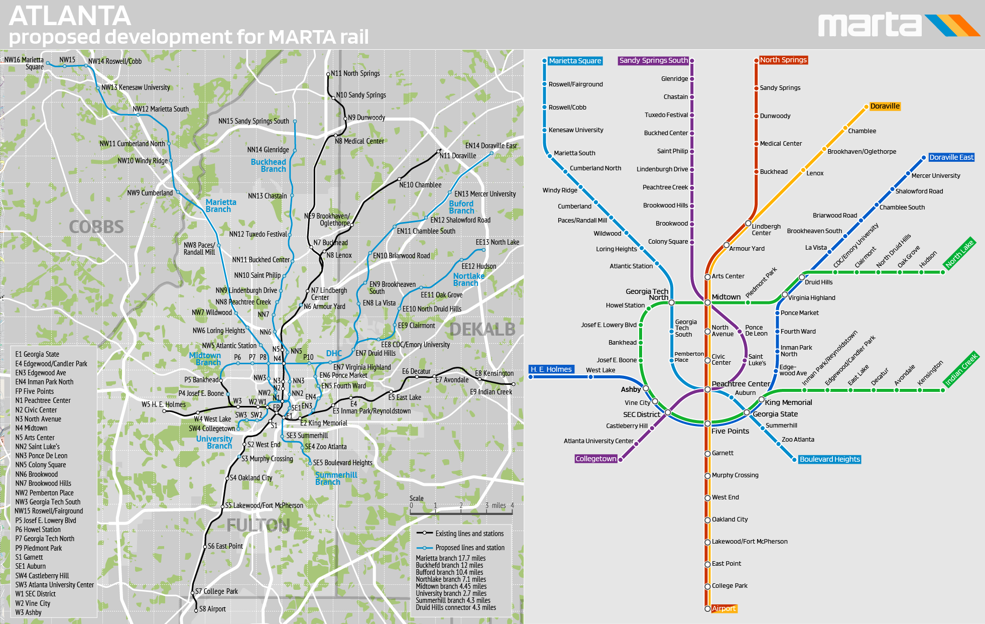
Atlanta, GA. Proposed development for MARTA rail The Atlanta metropolitan area has an estimated population of over 6.4 million and is the sixth-largest metropolitan area in the United States. Today, Atlanta commuters primarily choose to travel by car. 2022 census estimates show that, of workers commuting within the city, about 68% drove alone, 8% carpooled, and only 5% used public transportation. Atlanta has a reputation for bad traffic and has been ranked among the worst cities for commuters. For this reason, some planners and activists have advocated for improved alternatives to driving. This map shows the potential development of MARTA Rail, a rapid service that forms the backbone of the city's public transportation system. Currently, the system operates on 47.6 miles (76.6 km) tracks, serve 38 stations located on four service lines, and looks highly underdeveloped for a metro area of its size. The proposed new lines would traverse the city's densest development and connect key areas and sites lacking rapid public transportation. Given the current reality, this plan appears overly optimistic, but it does indicate a direction for potential development. |
|
|
|
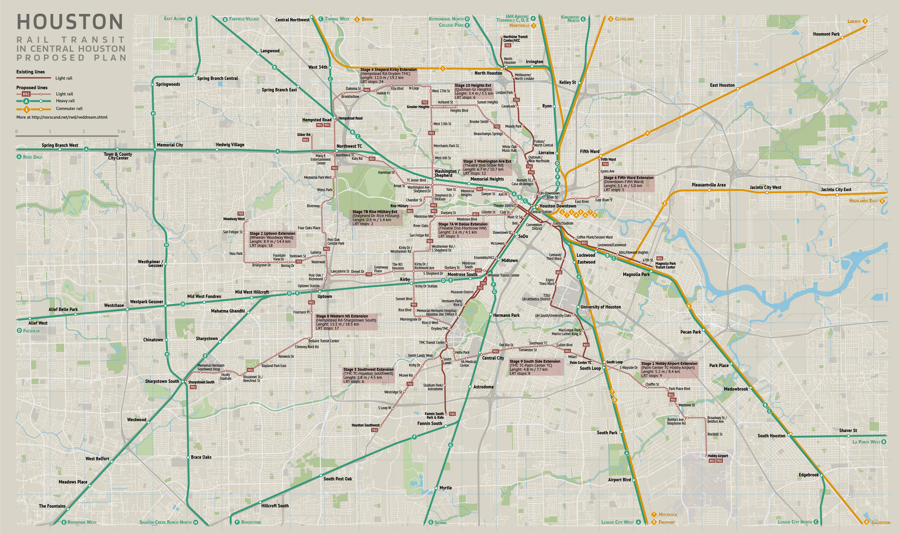
Houston, TX. Proposed plan of rail transit in central area Houston is the fourth-most populous city in the United States, with a population of 2.3 million and 7.8 million residents in The Greater Houston metropolitan area. Houston is considered an automobile-dependent city, with an estimated 80% of commuters driving alone to work. The Metropolitan Transit Authority of Harris County (METRO) provides public transportation in the form of buses, light rail, high-occupancy vehicle (HOV) lanes, and paratransit. METRO began light rail service in 2004 with the opening of the 8-mile (13 km) north-south Red Line connecting Downtown, Midtown, the Museum District, the Texas Medical Center, and NRG Park. In the early 2010s, two additional lines—the Green Line, servicing the East End, and the Purple Line, servicing the Third Ward—opened, and the Red Line was extended northward to Northline, bringing the total length of the system to 22.7 miles (36.5 km). This map shows the potential development of rail transit, particularly LRT, in the central part of the city. The plan includes a 32-mile gradual expansion of lines, tripling the total length of the current system.Another chapter is about the construction of the metro and commuter train network, an overview of which presented next. |
|
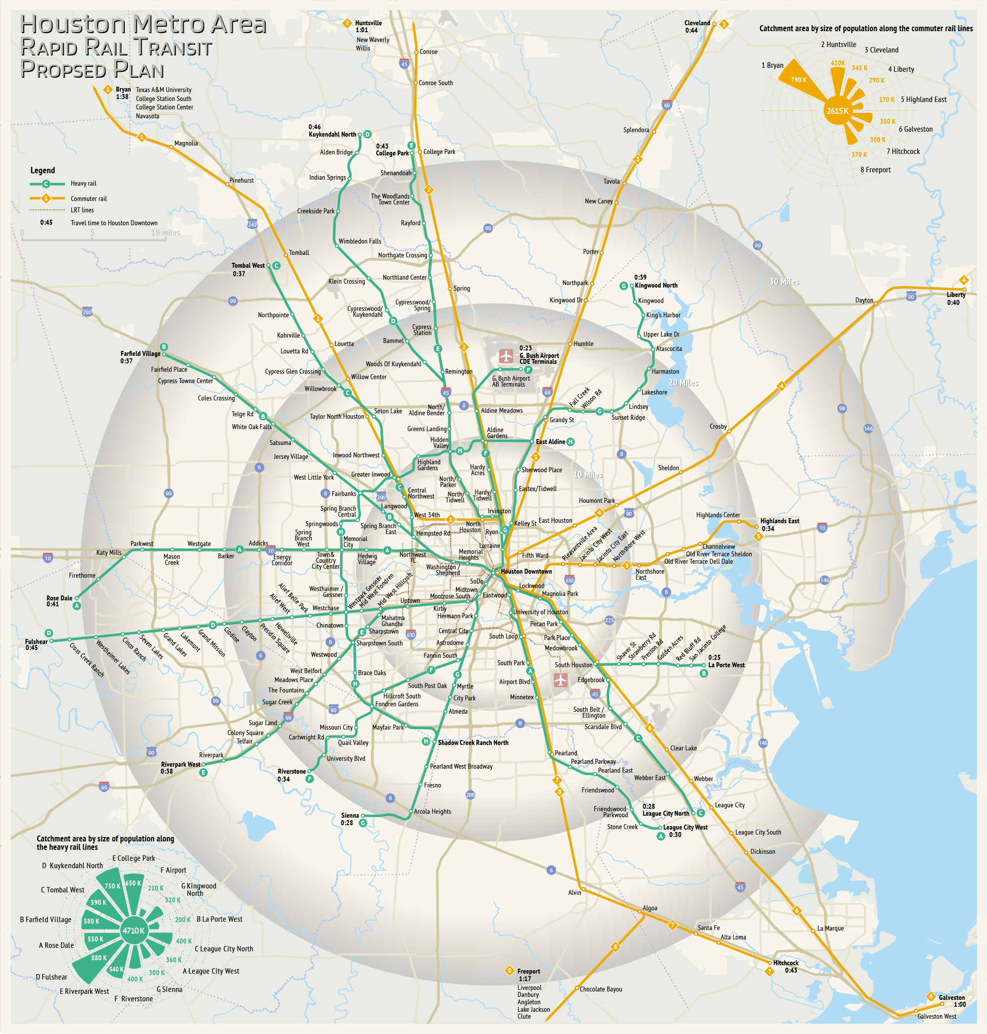
Houston, TX. Proposed plan of rapid rail transit in metro area The heavy rail transit plan consists of two systems: metro lines (heavy rail) and commuter rail lines, with a key hub located in downtown Houston. The metro system consists of eight lines, seven of which are connected into two intersecting diameters in the city center, while the eighth line is the western semicircle. This system is 355 miles long and has 184 stations/transfer hubs. The network structure is designed to maximize coverage of residential areas and to compete with the private car. An average speed of 46 mph (with a maximum speed of 130 mph) allows travel from all outer points to the downtown in approximately 40 minutes. Trains on each line operate every 5 minutes during rush hour and every 10 minutes off-peak. The system is planned to be constructed primarily as above-ground and elevated trains, with the exception of an underground section in the dountown. The commuter rail system consists of eight lines and 71 stations, serving the northern, eastern, and southern suburbs. All routes originate in the city center and can also serve as a faster option for inner-city areas. Average speed is 54 mph, with a maximum speed of 150 mph. The system spans 380 miles, with the longest route, to Bryan, covering 98 miles. Service frequency varies from every 10 minutes to every hour, depending on the line, its section, and the time of day. Construction is planned within existing rail corridors. |

|
Miami, FL. Proposed plan of rapid rail transit in metro area The heavy rail transit plan consists of two systems: metro lines (Metrorail) and commuter rail lines (modernised Tri-Rail), with a key hub located in downtown Miami. The metro system represents an expansion of the existing Metrorail rapid transit system, increasing its total length fivefold from 39 km to 194 km (118 miles). It comprises five lines and 146 stations. The network structure is designed to maximize coverage of residential areas and to compete with the private car. An average speed of 46 mph (with a maximum speed of 130 mph) allows travel from all outer points to the downtown in approximately 30-45 minutes. Trains on each line operate every 5 minutes during rush hour and every 10 minutes off-peak. The system is planned to be constructed primarily as above-ground and elevated trains. The commuter rail system of Tri-Rail consists of seven lines and 101 stations, serving the northern part of metro area. All routes originate in the city center (ex?ept ? 7 and can also serve as a faster option for inner-city areas. Average speed is 54 mph, with a maximum speed of 150 mph. The system spans 466 km (282 miles), with the longest route, to Jupiter North, covering 83 miles. Service frequency varies from every 10 minutes to every hour, depending on the line, its section, and the time of day. Construction is planned within existing rail and road corridors. |
|
 |
© 2007-2026 Norscand.Net | |