|
|
You are here:Home / Behind the maps / Understanding Gramen |
|||||
| Understanding Gramen | |||||
The world of maps and invented cities The map is one of amazing things invented by people. Will not someone really surprise the fact that not being in particular place he can see how it could be organized or even looks like? An inquisitive man was always interested in matter of the things. Child, who wants to know the device of his toy, tries to disassemble it anticipating a new discovery As for me, the deliberate discovery of the whole world has happened in my childhood just by way of maps. In my six, I was gifted by geographical atlas. To examine it was more interesting than any children's book with pictures. Later the desire to draw the seen things has come to me. Next, I became to devise and draw own maps localizing my interest around the city planning. At first, it was simple imitating drawings. Reading books on architecture and urban planning, taking an experience of famous examples I took definite vision about how comfortable for living city could look like. One of the embodied on the paper such visions you can see on presented map of Gramen city. |
|
Gramen as is Gramen is fully invented city in imagined country. Nevertheless, the combination of quite real functionality of American cities and humanity of European ones had an influence upon shaping of Gramen's face. The city center is presented by all necessary functions that peculiar to big modern city. There are business zones with its own skyscrapers but placed not so dense like in Manhattan. There are entertainment and culture districts - such towns in the city with adequate buildings to human size intermitting with parks and open spaces. There are also shopping malls and multifunctional centers here. Many recreation zones such as wide boulevards, promenades, linear and square parks separate mentioned zones. United in one pedestrian link without crossing roads on the same level, overground esplanades and tunnels provides good access by foot to all principal destinations. Highway network as well as extensive network of rapid transit makes easy accessible city center from other districts. Of course, in spite of obvious verisimilitude of presented city map, this plan cannot be realized. Too idealistic, too expensive. However, I guess it is better to move this way than to build beehive city of the future. Returning to map drawing, I would like to remark that is not only play of fantasy and pleasant time spending. It is useful exercise at practical point of view. It is development of strategy with interesting and true-like looking project as a result. |
|
|
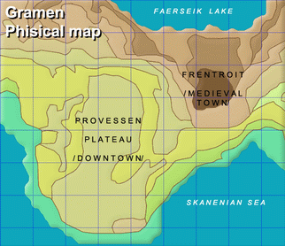
How Gramen was drawn. By legend (fiction history) being the capital of the country, Gramen is the largest city of polycentric agglomeration with population of 2.5 million people in the city and 4.3 million people in the whole metropolitan area. It was found as defensive fortress on the mountain situating between sea and Faerseik Lake in place of medieval part Frentroit at present time. While extending, city grew to the lake (northbound from Frentroit, where the sites of legislative and executive authorities are located) and alongside the seacoast; it reached the peninsula presented on map. The bigger part of peninsula is a wrong 8-shaped plateau that steeply goes down from 20-25 meters height to the seacoast with 500-800 meters by width and goes up 235 meters eastward to shape the flat top of the mountain with fortress and walls of medieval town. Complicated and interesting enough relief caused original radial-and-circular layout of streets and roads |
|
|
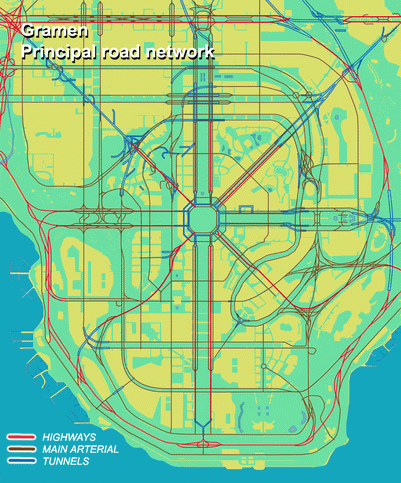
Center plaza, the core of downtown, is situated on intersection of 8 wide parade avenues each of it is dubbed with freeways. These roads connect downtown with other city wards. In turn, transversal links were added by circular arterials with multi-level junctions. At first, compiling the map, the street and road network forms with taking into account given relief and recreation zones. After, one determines the function of each part of city and localization of main objects. Then turn comes to develop the system of public transit. Gramen has advanced rapid transit network in form of acting within municipal borders subway with 7 lines and regional express rail service with 6 routes for connection in the whole metropolitan area. There is also commuter rail network. 60 % of social active inhabitants use public transit partly or in full everyday; the rest uses personal cars. When basement of the city is ready, time comes to think out about individual structures, additional driveways, layouts of junctions and rest details depending on map scale. Finally, you get ready map as a result of chosen strategy that dictates by own experience, knowledge and inner voice. In my humble opinion, Gramen is worthy project.
*** The
city's different and ever new *** |
| © 2007-2026 Norscand.net | |