| |
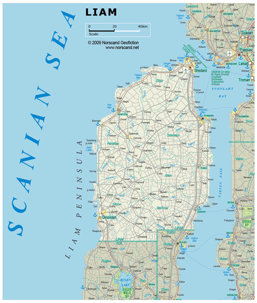
| General map (1239x1463, 0.32 mb) |
 |
| |
|
|
| Flag |
Coat of Arms |
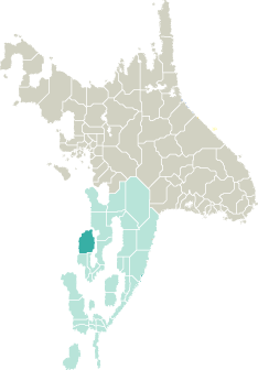
Location |
 |
 |
| Road maps for this area |
 |
|
| |
|
| Location |
Western Garand |
| Area |
 Continental Continental |
10 893 sq.km |
| Isles |
4 sq.km |
| Water bodies |
10 sq.km |
| Total |
10 907 sq.km |
| Rank in Garand |
9 of 35 |
| Rank in Norscand |
39 of 103 |
| Size comparision |
X |
| Boundaries |
| Land |
84 km |
| Coastal (w/o isles) |
465 km |
| Population |
| Total |
330 951 |
| Rank in Garand |
33 of 35 |
| Rank in Norscand |
57 of 103 |
| 5 Largest towns |
| Shedard |
99 026 |
| Dinonden |
50 900 |
| Sdaman |
46 124 |
| Pensten |
15 088 |
| Yorex |
14 488 |
| Administrative division |
| # of districts |
6 |
| County seat |
Shedard |
| Transportation |
| Roadways: |
|
| Total length (paved, basic network) |
6 296km |
| Expressways |
159km |
| Road density |
0,58 km/sq.km |
| Share of expw |
3% |
| Railways |
|
| Total length |
292km |
| High-Speed Lines |
0 km |
| Airports |
|
| Total |
7 |
| Sched.service |
1 |
| Seaports |
|
| Total |
8 |
| |
|
|
|


